Antigua & Barbuda
Antigua has a land area of 108 sq. miles located at latitude 17° 5' North and longitude 61° 45' West in the Leeward Islands of the Caribbean.
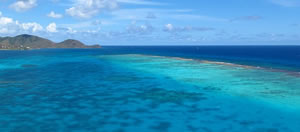
Antigua is about 13 miles across with a coastline peppered with numerous coves and bays, many with beautiful white-sand beaches. The south-west corner is hilly, rising to 402 meters at Boggy Peak, the island's highest point.
Barbuda, a low-lying coral island is located 32 miles north of Antigua and has a land area of approximately 64 sq. miles. Barbuda encompasses the expansive Codrington lagoon, which is bound by a long undeveloped beach.
The country's boundaries also include Redonda, and uninhabited rocky islet less than 1 sq. mile in size which lies 32 miles south-west of Antigua.
Specials
New And Featured


